
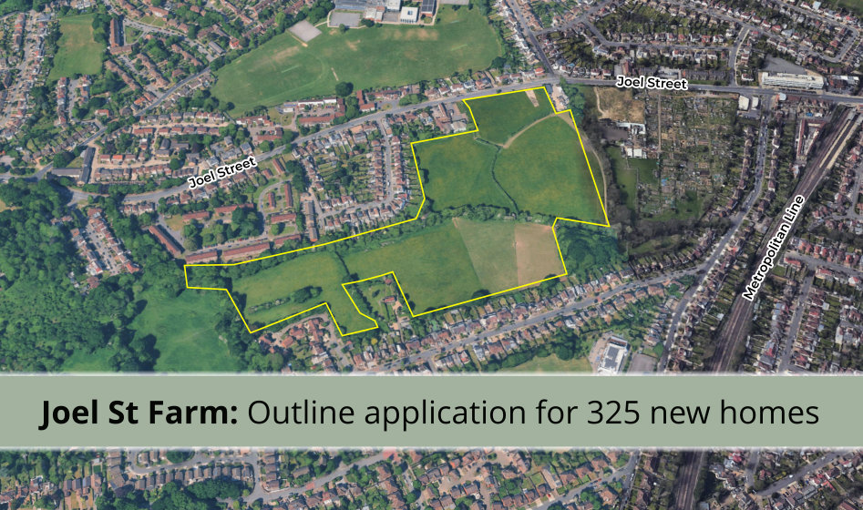
A new potential proposal has appeared on the council website for land at Joel Street Farm, Northwood Hills – around 10.8 hectares of horse-grazing fields off Joel Street, close to Northwood Hills Underground station.
This site sits within Northwood Hills, not Ruislip, so it’s the Northwood Hills Residents’ Association, and likely the neighbouring Northwood Residents Association and Eastcote Residents’ Association, who will be most directly involved as the scheme progresses. But many Ruislip residents will know Joel Street well, and the local residents’ associations work closely together and share information across boundary lines – so we’re covering it here too, and will point readers to Northwood Hills RA’s own updates as the application develops.
What is being proposed?
The landowner, Charterhouse Strategic Land, working with agent HTA Design LLP, is preparing an outline planning application for a residential-led redevelopment of the site. The emerging proposals include:
- Up to 325 new homes (Use Class C3), with 50% affordable housing – above the Local Plan requirement. The developer’s own evidence points to strong borough-wide demand for larger family homes, particularly three-bedroom properties, though the precise mix of home sizes hasn’t been set out in detail yet.
- Housing mostly 2–3 storeys, rising to a maximum of 5 storeys in places, designed to reflect the surrounding Metroland suburban character
- 50% of the total site area (around 5.4 hectares) retained as publicly accessible open space and green infrastructure
- A minimum 10% biodiversity net gain, delivered on site through habitat and watercourse enhancements
- Improved walking, cycling and public transport connections to Northwood Hills local centre and station (500m/around a 6-minute walk north of the site), alongside cycle parking and EV charging – full details of vehicle access and parking will be set out in the Transport Assessment accompanying any future application
The site currently comprises several grazing fields divided by hedgerows and trees, with a small tributary of the River Pinn running north–south through the middle. It’s bounded by suburban housing to the east and west, allotments and an equestrian centre to the north, and Green Belt woodland to the south.
This proposal doesn’t replace the the vets or nursery
If you drive along Joel Street, you’ll recognise Joel Street Farmhouse and its outbuildings – now home to the Joel Street Veterinary Clinic and the Blossom Tree Montessori Nursery. To be clear: these buildings sit just outside the application site boundary, to the west, and are not proposed for demolition or redevelopment.
They are, however, locally listed heritage buildings, and the developer’s own initial assessment acknowledges that building new homes on the adjoining fields would cause a low level of harm to their setting – in other words, the character and context around them would change, even though the buildings themselves stay as they are. Similarly, the Grade II listed White Cottage, which the site wraps around on three sides, is also outside the site boundary but flagged for the same reason.
Is this going to get planning permission?
There is no planning application to approve or reject yet. What’s currently registered (ref. 8856/APP/2026/2112, case officer Sally Robbins) is an EIA Screening Request – a preliminary technical step that only asks the council to confirm one thing: whether a full Environmental Impact Assessment (a lengthy, in-depth study of traffic, ecology, noise and so on) will need to accompany the eventual application. It doesn’t ask the council to judge the merits of the scheme itself, and it isn’t open for public comment.
Here’s roughly how the fuller process is likely to unfold from here:
- Screening decision – the council decides whether an EIA is required. A decision is expected by 15th September 2026.
- Pre-application exhibition (likely, but not guaranteed) – developers of schemes this size will often hold an informal public exhibition before they finalise their application, to show local residents their emerging plans and gather feedback, which they can then use to adjust the scheme. This is not a legal requirement and has no statutory weight, but it’s common practice and something we’ll flag if and when it’s announced.
- Full outline planning application submitted – likely several months away, and only once the above steps are complete and Charterhouse Strategic Land considers the scheme ready.
- Formal statutory public consultation – once an application is formally submitted and validated by Hillingdon Council, it must go through a formal, legally required public consultation. This is the point at which every resident can view the detailed plans and submit their own comments or objections for the planning department to consider before a decision is made.
So while it’s natural to want to know whether this will be built, there’s no scheme to approve yet, and residents will get a proper, formal opportunity to have their say once – and if – a real application is lodged.
We will get to see more of Hillingdon’s internal assessments
As covered in the August 2026 Town Crier, residents’ associations have been pushing Hillingdon Council to make specialist reports – such as Highways, heritage and archaeological consultation responses – properly visible on the planning portal alongside any future application, rather than only obtainable through Freedom of Information requests. The council has committed to a new planning portal by Easter 2027, so by the time a full application on this site is submitted, residents should have much better visibility of the technical reports (e.g. on transport, ecology and flooding) than has sometimes been the case in the past.
Who actually decides whether this site gets built on?
It’s worth remembering that Hillingdon Council – not the Mayor of London or central government – is the planning authority that will ultimately determine any application on this site. As our earlier article, Who really decides where we build?, sets out, the Mayor’s London Plan sets overall housing targets for the borough and identifies broad areas (such as land near certain stations) where Green Belt release might be considered – but it’s Hillingdon Council’s own Local Plan, and ultimately its planning committee, that decides whether any specific site, like this one, is actually released from the Green Belt and granted permission.
The same article details that Hillingdon Council’s own timetable for formally reviewing specific Green Belt sites and proposing boundary changes as part of its Local Plan isn’t due to begin until around June 2027 – well after this screening decision, and likely before any full application here as well.

Approximate outline of the proposed development site
What’s this “Grey Belt” argument about?
The developer’s submission argues this site should be treated as “Grey Belt” land rather than ordinary Green Belt.
In plain terms: in December 2024, the Government changed national planning rules to introduce a new category of Green Belt land – nicknamed “Grey Belt” – where the land is judged to do very little to serve the traditional purposes of the Green Belt (such as stopping towns from sprawling into each other), typically because it’s already hemmed in by existing development on most sides. Where land qualifies as Grey Belt, it can be treated more favourably for housing development than land that plays a genuine role in keeping the Green Belt open.
The developer points to a Greater London Authority assessment published in July 2026, which reviewed Green Belt parcels across London and concluded this particular parcel (referred to as “Parcel HI41”) makes only a “weak or no” contribution to Green Belt purposes, because it’s largely surrounded by existing housing rather than open countryside.
This is the developer’s own characterisation of a third-party assessment, not a decision by the council – and whether Hillingdon Council agrees with it, and how much weight it gives it, will be a central question for any future planning committee, not something settled by this screening request.
Does the site raise environmental concerns?
The submission does flag several matters that will need proper technical assessment before any application can be approved:
- A Site of Importance for Nature Conservation (SINC) follows the watercourse corridor through the site, and Ruislip Wood SSSI/National Nature Reserve lies around 0.6km to the west
- Surveys so far have identified a possible badger sett near the northern boundary and trees with features that could support roosting bats, with further survey work ongoing
- Most of the site sits in Flood Zone 1 (low flood risk), but the strip following the watercourse falls within Flood Zones 2 and 3 (higher flood risk) – hydraulic flood modelling by Stantec found flood depths of up to 0.37 metres there in extreme weather, which is one reason the emerging masterplan keeps homes out of the central river corridor and uses it as green space instead
- An initial heritage review concludes the scheme would cause a low level of harm to the setting of both White Cottage and Joel Street Farm, as explained above
To be clear about what the screening request is actually arguing here: the developer isn’t saying these issues don’t matter. It’s saying that, in its view, they’re the kind of issues that can be properly investigated and controlled through the normal suite of technical reports (ecology, flood risk, heritage, transport, landscape) and planning conditions that accompany any planning application – rather than needing the additional, more exhaustive study process that is a full Environmental Impact Assessment. Whether the council agrees with that judgement is what the screening opinion, due by 15th September, will decide.
Has anything happened on this site before?
Yes – in February 2023, the council approved a smaller application to relocate the site’s field access on Joel Street and form a vehicular track to the existing farm building. That permission was never implemented.
TL;DR
There is no application to comment on yet, and this screening request does not involve public consultation. We’ll continue monitoring this site alongside Northwood Hills and Eastcote Residents’ Associations, and will update residents at each stage set out above – including if a pre-application exhibition is announced.

Comments are closed.